


Day_1.1

gue
User

Length
5 km

Max alt
37 m

Uphill gradient
40 m
Km-Effort
5.5 km

Min alt
16 m

Downhill gradient
40 m
Boucle
No
Creation date :
2014-12-10 00:00:00.0
Updated on :
2014-12-10 00:00:00.0
2h00
Difficulty : Unknown

FREE GPS app for hiking
 SityTrail
IGN / Geographical institutes
SityTrail Plus
The world is yours!
About
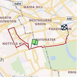
Trail Other activity of 5 km to be discovered at England, London, Royal Borough of Kensington and Chelsea. This trail is proposed by gue.
Positioning
Country:
United Kingdom
Region :
England
Department/Province :
London
Municipality :
Royal Borough of Kensington and Chelsea
Location:
Unknown
Start:(Dec)
Start:(UTM)
694573 ; 5710174 (30U) N.
Comments